The 7 most beautiful mountain lakes in Zillertal
How quickly the color of a mountain lake can change is incredible. If the sky is cloudy, it appears in gloomy, dark gray to dark green colors. When the sun breaks out, everything changes within minutes. The reflection of mountains, trees and plants make the moment so unique that you don't want to leave. According to your taste, you will reach many idyllic mountain lakes in our nearby surroundings, which will make you calm and simply happy.

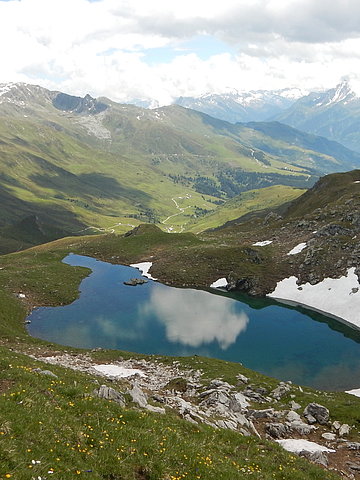
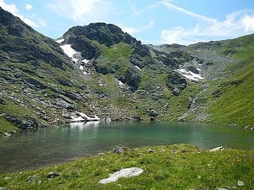
Junssee (2.700m)
Starting point: Almkäserei Stoankasern
End point: Hotel Eden
Walking time: approx. 6.5 hours / approx. 16 km route
Ascent: 1.123hm Descent: 1.756hm
Special features: Almkäserei Stoankasern - in the morning you can watch here how the alpine dairyman makes cheese. The cheese can of course also be tasted at the snack station.
The ascent to the alpine cheese dairy Stoankasern takes place with the hiking cab. Here the hike starts over the "Toten Böden" to the crystal clear Junssee, which is embedded in a sea of boulders. From here it is only a short climb to the highest point of the hike, the Geier (2,857m). Over the Junsjoch and along the Via Alpina you come back to the alpine dairy Stoankasern. Here you can fortify yourself once again before the descent via the forest path to the Hotel Eden.
Bike & Hike: This hike is perfect as a bike & hike tour from Hotel Eden. The bikes can be parked at the Jausenstation Stoankasern.
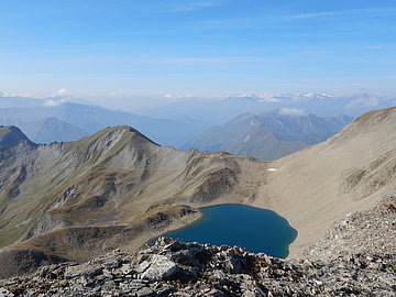
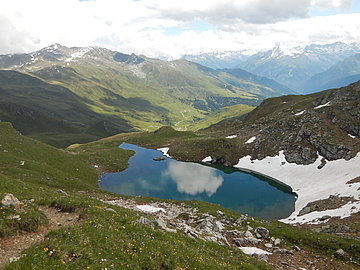
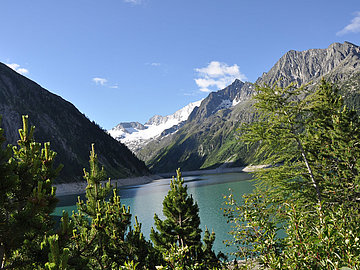
Eiskarsee (2.360m)
Starting point: Parking lot Geiselhöfe
End point: parking lot Geiselhöfe
Walking time: approx. 5 hours / approx. 14.5 km route
Ascent and descent: 757hm
Special features: The hike is located in a scenic, unique basin and can also be extended with summit ascents on the Eiskarspitze (2,611m) or the Hippoldspitze (2,643m).
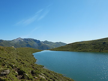
From the parking lot below the Geiselhöfe, the trail leads past the Geiselalm and the Hobalm to the Vallruckalm. Here the hiking trail branches off to the Eiskarsee, which can now be reached in about 30 minutes. Embedded in the surrounding mountains, this is a wonderful place of power. The way back is back to the Vallruckalm and via the Nederjoch and the Nasse Tuxalm to the starting point.
Bike & Hike: The Eiskarsee is also possible as a Bike & Hike tour from the Hotel Eden. The ascent with the bikes is possible up to the Vallruckalm.
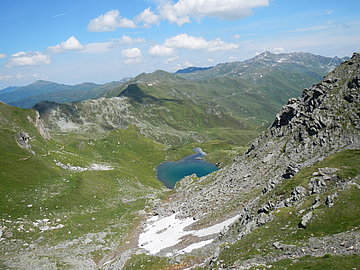
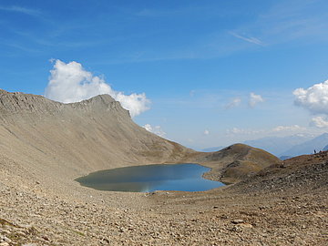
Torsee (2.275m)
Starting point: Eggalmbahn mountain station
End point: Eggalmbahn valley station
Walking time: approx. 4.5 hours / 12 km route
Ascent: 510hm Descent: 1.110hm
Special features: Regular guest cross on the Ramsjoch, Rosenzkranz chapel.
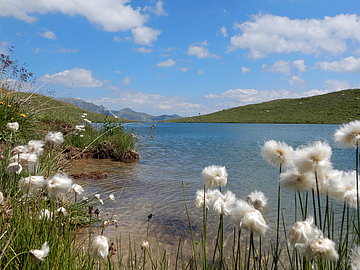
From the Eggalmbahn mountain station at 2,000m, the trail leads across lush alpine meadows to the Grübelspitze (2,395m). After a short descent, it goes over some serpentines to the Ramsjochspitz (2508m). Here you will find the regular guest cross of the TVB Tux-Finkenberg. The wildly romantic Torsee lakes, surrounded by white cotton grass, are already visible from here and can be reached in about 20 minutes. The descent takes place past an impressive waterfall to the "Nasse Tuxalm" and further through the farm settlement Gemais, past the Rosenkranzkapelle to the Eggalmbahn valley station.
Bike & Hike: The Torseen are also beautifully accessible as a Bike & Hike tour from Lanersbach. Parking for the bikes is above the Nasse Tux Alm.
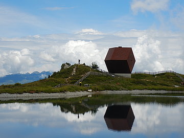
Speichersee Penken with Garnet Chapel (2.087m)
Starting and end point: mountain station Finkenberger Almbahn
Walking time: 20 minutes
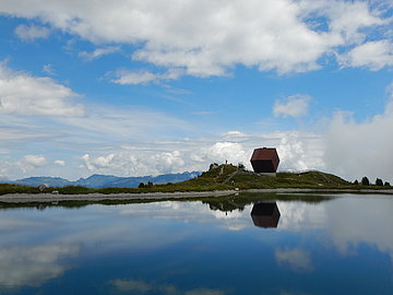
Special features: The Garnet Chapel or "Capella Granata" by architect Mario Botta is located on the sunny plateau of the Penkenjoch, directly at the reservoir. It uniquely combines the nature of garnet stone, which was mined in the Stillupp Valley in the past, and local woods.
The reservoir Penken is easily accessible for everyone with the Finkenberger Almbahn. A 20-minute walk around the lake offers wonderful views of the surrounding mountains. The highlight is the Garnet Chapel.
Bike tour: For sporty bikers, the reservoir can also be reached with an ascent via Astegg. With subsequent descent to Vorderlanersbach offers a great round trip.
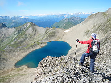
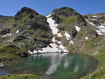
Rastkogelseen (2.400m)
Starting point: Parking lot Geiselhöfe
End point: parking lot Geiselhöfe
Walking time: approx. 4.5 - 5 hours / 12 km route
Ascent and descent: 954hm
Special features: Unique view of the mountain world of the Zillertal Alps.
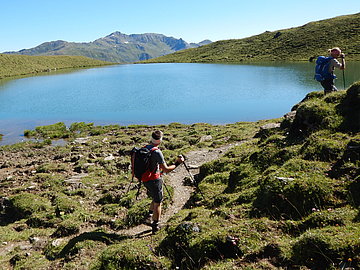
From the parking lot below the Geiselhöfe, the trail leads via the Geiselalm, always slightly ascending, up to the Rastkogel lakes. Once arrived, you have a beautiful view of Tux and the imposing view up to the Rastkogel (2,762m). After another short ascent, the route continues along the ridge via the Nurpsenjoch and the Nafingjoch to the Geiseljoch. From there the descent to the Geiselalm and back to the starting point.
Bike & Hike: Rastkogelseen is also possible as a Bike & Hike tour. Here you come with the bike from the Hotel Eden to the Geiselalm.
Speichersee Zillergrund (1.850m)
Starting point: Gasthof Adlerblick
End point: Gasthof Adlerblick / Bärenbadalm
Walking time: 2,5 hours / 5km route
Ascent and descent: 126hm
Special features: On the hike along the reservoir, there are countless wooden benches and life lessons that encourage you to linger and reflect. The Gasthof Adlerblick at the Speichersee is an imposing building directly on the steep rock face.
From the parking lot at Gasthof Bärenbad in the Zillergrund, the shuttle bus will take you comfortably to the starting point at the dam wall/Gasthof Adlerblick at 1,900m. From the top of the dam, a wide path leads mostly level always along the lake into the valley. After a little over 1 hour you reach the Hohenaualm, the Little Tibet of Tyrol, which awaits you with a prayer mill and colorful waving flags. (Possibility to stop for a break). The way back follows the same route and, depending on your condition, can also be as far as Gasthof Bärenbad.
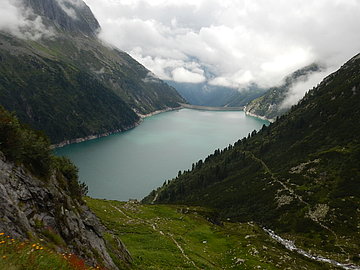
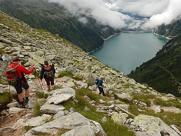
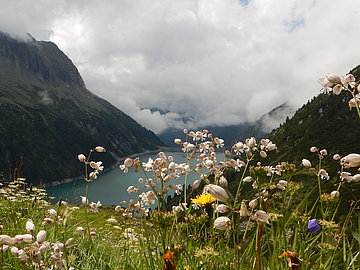
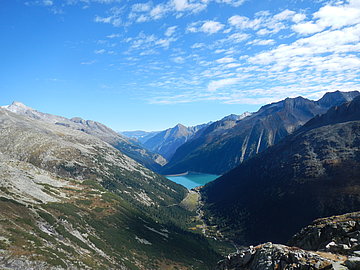
Schlegeisspeichersee (1.850m)
Starting and ending point: parking lot Schlegeisspeicher
Walking time: 3 hours / 6km route
Ascent and descent: 600hm
Special features: Above the Olpererhütte is the well-known photo point on the suspension bridge with a view of the reservoir.
From the parking lot at the reservoir, the trail leads in serpentines first through a forest. Then the view of the surrounding mountains and the reservoir opens up and after about 1.5 hours of continuous ascent you reach the Olpererhütte with a beautiful view. The descent is either on the same route or via the Neumarkt loop back to the parking lot.